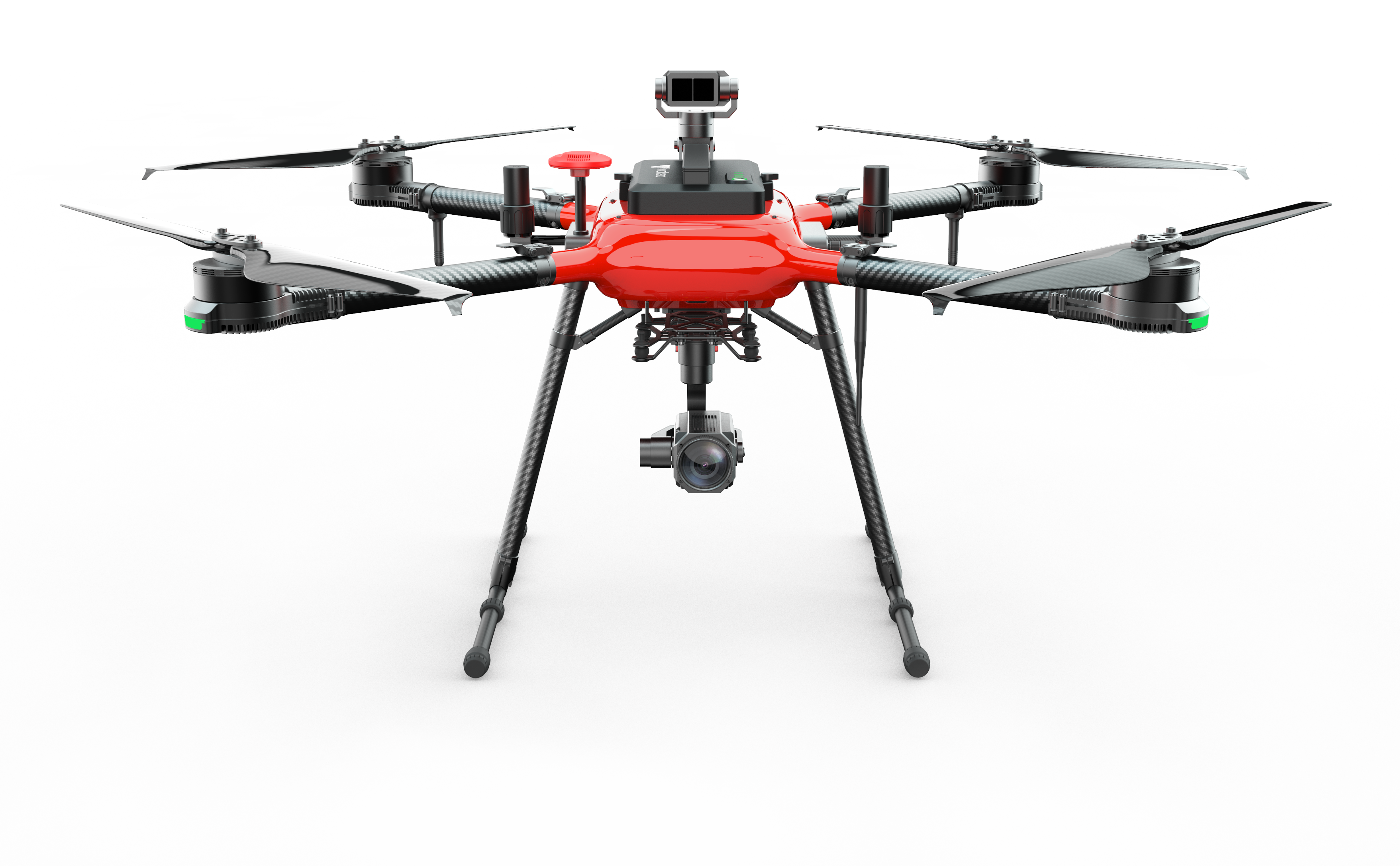
The SATIR UAVX640 is a cutting-edge drone designed for optimal performance and safety. Featuring a modular, foldable design, it is highly portable and easy to deploy. Equipped with dual magnetic compasses and a GNSS+grid RTK system, the UAVX640 offers precise positioning and navigation, ensuring reliable flight operations. Its advanced obstacle avoidance system, including 360-degree sensing, significantly enhances safety. With a long flight time of 54 minutes and a substantial payload capacity of 8kg, this drone is capable of handling demanding tasks. The UAVX640 also boasts a robust build, with IP54 protec- tion against water, dust, and corrosion, making it suitable for various environmental conditions.
Key Features
|
Aircraft |
|
|
Symmetrical motor wheelbase |
1047mm |
|
Outline size |
1140mm x 1140mm x 531mm (Arm extended, blade folded) |
|
514 mm x 439 mm x 469mm (Arm Folded) |
|
|
Motor |
kv value: 180rpm/v |
|
Electric regulation |
Continuous current: 80a (Good heat dissipation condition) |
|
Blade specification: diameter pitch |
24x7.9 inch |
|
Standard take-off weight |
7.8kg (including battery) |
|
Maximum take-off weight |
15.8 kg (sea level) |
|
Maximum rising speed |
5 m/s |
|
Maximum descent speed |
3 m/s |
|
Maximum horizontal flight speed |
GPS mode: 5m/s (windless environment), Cruise mode: 3-20m/s adjustable (windless environment) Attitude mode: 25m/s (windless environment) |
|
Maximum pitch angle |
positioning mode: 40°, Cruise mode: 40°, Attitude mode: 40° |
|
Maximum rotation speed |
Pitch axis: 100 °/S |
|
Maximum allowable wind speed |
17m/s |
|
Maximum flight time |
54minutes (no load) |
|
Maximum flight altitude |
5000m |
|
Recommended operating temperature |
0℃~ +40℃ |
|
Hover accuracy (with rtk) |
vertical: ± 10cm horizontal: ±5cm |
|
Hover accuracy (Without rtk) |
vertical: ± 0.5 m horizontal: ± 0.1 m |
|
Laser radar obstacle avoidance system |
|
|
Obstacle sensing range |
0.5m-40m @90% reflectivity (100Klux), 0.5m-13.5m @10% reflectance |
|
FOV |
Horizon 3° |
|
Measuring frequency |
50 Hz |
|
Yaw |
360° |
|
Pitch |
±90° |
|
Detection distance |
≤ 40 m |
|
Network RTK |
|
|
Frequency band |
GPS: L1/L2/L5
GLOINASS: F1/F2 Beidou: Bl/B2/B3 Galileo: E1/E5 |
|
Orientation accuracy |
0.2 °/1m baseline, Horizontal: 1cm+1ppm |
|
Positioning accuracy |
Level: 1cm+1ppm, Vertical: 2cm+1ppm, 1ppm: for every increase of 1km, The accuracy will deteriorate by 1mm. |
|
Positioning update rate |
1hz, 2hz, 5hz, 10hz and 20hz |
|
Cold start |
<45s |
|
Hot start |
<10s |
|
Recapture |
<1s |
|
Initialization reliability |
>99.9% |
|
Differential data transmission format |
Rtcm 2.X/3.X |
|
Data link |
4g |
|
Communication distance |
Unlimited distance (with 4g network signal) |
|
Working environment temperature |
0°C to 45°C |
|
Infrared Thermal Imaging |
|
|
Detector Type |
Uncooled Vanadium Oxide Focal Plane Detector |
|
Resolution |
640 X 512 (1280x1024 Optional) |
|
Spectral Range |
8μm~ 14μm |
|
Thermal sensitivity (NETD) |
≤40mK@f/1.0 |
|
Focal length |
13mm |
|
Video resolution |
640*512@30fps |
|
Measurement Mode |
Point temperature measurement, Area temperature measurement, Max/Min Temperature |
|
Colour palette |
White hot, black hot, rainbow iron red, amber, etc. |
|
Temperature Range |
-20℃ - +550℃ |
|
Photo shooting mode |
Single shot\continuous shot\timed shot |
|
Image Format |
TIFF |
|
Laser Ranging |
|
|
Wavelength |
905mm (eye-safe) |
|
Measuring range |
2~1500m |
|
Distance measurement accuracy |
±(0.2m+Dx0.15%), where D represents the distance from the vertical reflecting surface |
|
Camera |
|
|
Image sensor |
1/2.3inch SONY IMX117 CMOS |
|
Lens Pixel |
12M Pixels |
|
ISO range |
100-3200(video)/100-6400(photo) |
|
Video resolution |
4K 30fps |
|
Photo resolution |
3840x2160 |
|
Focal length |
6.7-134.5mm |
|
Focus time |
7-8 seconds |
|
Zoom magnification |
30 X optical zoom |
|
Doubling speed |
About 2.0 seconds |
|
Horizontal perspective |
59.8°-3.0 (wide angle-telescope) |
|
Close range |
more than 5000mm (wide angle-telescope) |
|
Max. Video bit stream |
64Mbps |
|
Compression standard |
H.264/H.265 |
|
Supporting file storage format |
JPG/MP4 |
|
Support memory card type |
Micro-SD card, Max. support:128G, transmission speed of Class 10 or above or up to UHS-1 rating Micro SD card |
|
Gimbal |
|
|
Input voltage |
12v |
|
Size |
136*98*139mm |
|
Weight |
452g |
|
Stabilization system |
3 axes (pitch, roll, yaw) |
|
Accuracy of angle control |
static: ±0.008°; dynamic: ±0.02°; Anti-shake: ±0.008° |
|
Controllable Rotation Range |
Pitch: -110°to+60°; Horizontal: ±150°; roll: ±10°; |
|
Max control speed |
pitch: 30°/s°; horizontal: 30°/s°; Roll: direct control angle |
|
Downward View with Fixed Height Module |
|
|
Speed measurement range |
Flying speed <18km/h (height: 2 m, sufficient light) |
|
Altitude measurement range |
≤ 12 m |
|
Precise hovering range |
±0.1m |
|
Measurement frequency |
100hz |
|
Remote control SATIR – S12 |
|
|
Model |
SATIR-S12 |
|
Operating frequency |
2400MHz to 2483MHz |
|
Maximum communication distance |
12KM (open without shelter, no electromagnetic interference) |
|
Display equipment |
5.5-inch 1920*1080, 1000NITS highlight screen |
|
Charging interface |
Type-c |
|
Battery |
3.7V 10000mAh LiPo 1S |
|
Endurance time |
8-24 hours |
|
Operating temperature |
-10°C to 40°C |
|
Charging ambient temperature |
5°C to 40°C |
|
Weight |
600g |
|
Size |
190*152*94 mm |
|
Intelligent Flight Battery |
|
|
Voltage |
45.6V |
|
Capacity |
1400mAh |
|
Discharge rate |
10C |
|
Battery type |
LiHV 12S |

